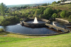
Bottoms Gauging Basin
I went for a walk yesterday around Arnfield Reservoir with Gail and Adam. It was a blisteringly hot day again with very little wind. We stopped for a rest in the shade of the beeches near Arnfield Bridge. Arnfield Reservoir is still very low; United Utilities have drained it to supposedly dredge some of the sediment out, which is something they used to do fairly regularly. This time however they seem to be keeping the water level low and the fly fishing facilities that used to be there look like they are not going to be used again. Adam took a few pictures including one of a very tame white pigeon. The landscape round the reservoir is particularly unattractive at present so I thought I'd post a picture of Bottoms gauging basin.
When Bottoms Reservoir was built in the 1870's the owners of the mills further down the river Etherow insisted on the Gauging Basin being built. This was to make sure adequate water was paid into the river as'compensation' for that impounded in the reservoir. Without thisthe dam would stop the natural flow of water supplying the mills with power. To ensure the millowners obtained the water due to them, the gauging basin would be filled with water for a certain time and a secret depth gauge would check whether the flow of water was correct.
For some reason the architecture around these Victorian waterworks is a peculiar obsession of mine. I am not the only one. If you have a few minutes take a look at the website of a group of people who have been mapping The Hodder and Thirlmere Aqueduct Access Gates. It is a fine example of the obscure pastimes people pursue on the Internet and the authors themselves describe it as "a totally unproductive and meaningless exercise". But I find it fascinating. It also has some information about the Longdendale Valley Reservoirs - 'my' reservoirs.


0 Comments:
Post a Comment
Subscribe to Post Comments [Atom]
<< Home